Wednesday, September 28, 2011

Cincinnati Birth and Death Records, 1865-1912


When I first became interested in genealogy, I remember making an appointment and going to the Hamilton County Health Department to look through index cards that recorded some early Cincinnati births and deaths.  I was struck with how easy it would be to just pocket specific cards and walk out with them.  As I recall, one of the people who assisted me said that cards could be missing.

At some point, the cards were given to the University of Cincinnati Blegen Library where many archives are stored.  I was thrilled when I learned that these cards were being digitized.  Apparently, that task has largely been completed.

There is a FAQ about this collection on the U.C. site:

Question: What is the scope of this collection and its history?
Answer: With a few exceptions, the official death records for the City of Cincinnati begin in 1865 and those for birth in 1874. As a result of a government records program of the Ohio Network of American History Research Centers, in 2003 over 500,000 card files from the Cincinnati Health Department were transferred to the UC Libraries' Archives and Rare Books Library. The cards contain the official records of births and deaths for Cincinnati citizens from the beginning dates as noted through 1908, with additional records through 1912. These cards are sometimes typed and many times handwritten, and were created by the Cincinnati Health Department several decades ago to preserve the data originally entered in ledger books. The ledger books are also preserved in the UC Libraries, but are of such fragility that any turning of the pages results in flaking and tears. The informational cards are considered the official and legal records of births and deaths for this time period.
While the bulk of these records begin in 1865, a small number of records show earlier dates. It is believed that these early records reflect the "restoration" of vital documents by citizens after the 1884 Hamilton County Courthouse fire, and were eventually sent to the City of Cincinnati Health Department for recording.
There are several different techniques for searching the database.  I found one of the most useful ways was to search by "subjects." An alphabetical list will come up and you can search by the surname that interests you.  Even with a surname like "Jones" I had reasonable results.


As anticipated, I was able to find information on some of my family members and not others.  "Deaths" are usually recorded on orange index cards.   Pictured is one that I found for my great-grandmother, Rachel A. Jones.


Once you've clicked on this record, you will be able to click on the "full" record. A lot of information is provided, not only on the person you are researching, but also a complete documentation of the history of the record.  Some of the information is pictured below.


A careful reading of the FAQ explains the few exceptions that have not yet been digitized.  However, I think you would agree that this may be a wonderful new opportunity to research many of our Cincinnati relatives at an important time in our city's history.

Monday, September 26, 2011

Mappy Monday: Mapping Morehouses in Cincinnati

My Morehouse and Warwick families had largely left Cincinnati by the time that Sanborn maps are viable research tools.  But, I'm hoping that the maps can help me solve the mysterious disappearance of Sarah Jane 'Sallie' (Morehouse) Warwick (1846- ).  If nothing else, understanding more about the community she lived in might help locate her in other records.

Sallie was a young widow found living in her mother's boarding house on 32 McFarland Street in the 1880 Federal population census.  She also appears in the Cincinnati city directory for the last time in 1880.  Her mother, Mary Ann (Rees) Morehouse, continues to be listed in directories intermittently until her death in 1894. Between 1880 and 1894, Mary Ann lived on 32 McFarland, 180 West 3rd, 199 Everett and 7 Gorman Street.  I'll start with Mary Ann and see if there are some clues in her neighborhood.

At the time of her death in 1894, Mary Ann lived at 7 Gorman Street, Cincinnati, Ohio.  There are two Sanborn maps that might give me information about the house - 1887 and 1891.  Both of these maps are available on microfilm at the Public Library of Cincinnati and Hamilton County.  But, I'm not at the library, so I'm looking to see what I can find out about the neighborhood on the 1904 Sanborn map which is available online the the PLCH Virtual Library.  I'll check out 1887 and 1891 later.

From the index, I learn that Gorman Street is on Map 80.  But, looking at the map, I don't see 7 Gorman Street.  Doug Magee warned us not only about street name changes but also numbering changes.  I remembered that Mary Ann (Rees) Morehouse had a daughter that continued to live on Gorman Street.  The 1896/97 directory gives Alice McLean Morehouse's address as 1507 Gorman Street.  Bingo!  (I'd still like to confirm this is the same house in other sources.)

Cincinnati, Public Library of Cincinnati and Hamilton County.  "Insurance Maps of Cincinnati, Ohio, Vol. 1."  Virtual Library.  http://virtuallibrary.cincinnatilibrary.org/lib/31/468/R912_77199_ef_S198_v__1_p__80.pdf  : 2011.
Several things immediately jump out.  First, Armory Avenue (once Everett) is in very close proximity so even though Mary Ann moved from 199 Everett to 1507 Gorman it was likely a move within the same neighborhood.  From Doug's talk, I know that the 'F' indicates that the building was a Flat (apartment) and that it was 3 stories high.  The pink coloration tells me the building was brick.  The 'D' designates a dwelling so this was a largely residential neighborhood.  A larger view of the map gives additional neighborhood information including other churches and businesses - perhaps sources of additional information!

This neighborhood is very close to the boundary between maps so I also looked at the map of properties south of Armory Avenue (map 72).  And much is made clear!  Mary Ann (Rees) Morehouse's daughter, Alice M. Morehouse was a schoolteacher.  In Map 72, we see that the flat where mother and daughter resided was very close to the 11th District Public School.  This is good news and bad news.  It does provide new information about the likely place that Alice worked but it is also possible that the family's living arrangements were driven by proximity to the school rather than proximity to other family members.


Cincinnati, Public Library of Cincinnati and Hamilton County.  "Insurance Maps of Cincinnati, Ohio, Vol. 1."  Virtual Library.  http://virtuallibrary.cincinnatilibrary.org/lib/31/468/R912_77199_ef_S198_v__1_p__72.pdf  : 2011.
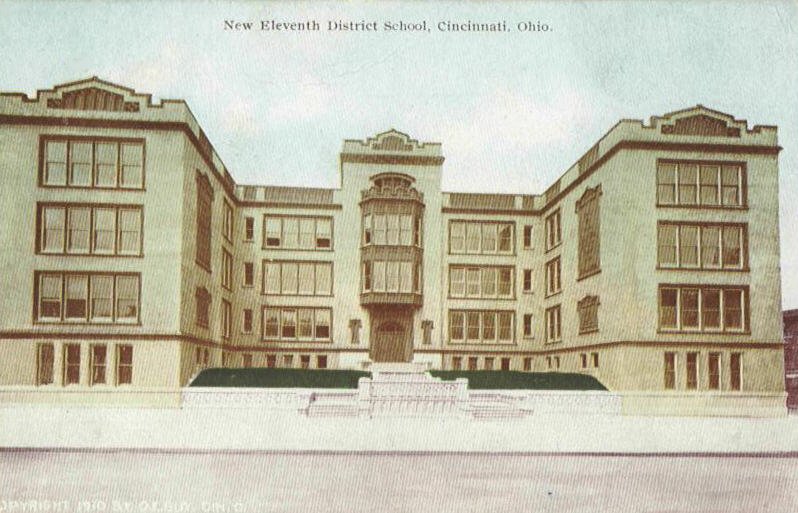
I always like to see pictures of the places my ancestors lived and worked.  I've looked for a photo of Gorman before without success.  This time I searched for images of the 11th District Public School and found images of the Washburn School on Clinton between Linn & Baymiller. The interesting thing is that one of the images is  Old Eleventh School District 1907 and notes that the school is about to be destroyed.  Another image is a postcard depicting the New Eleventh School District.  Since the map above is the 1904 Sanborn map, one might assume that it is the Old Eleventh School on the map.  Guess again!

This is one of the tricky things about the 1904 Sanborn map that Doug Magee warned us about.  Because of the exorbitant cost of producing maps, from 1904-1930, corrections were simply pasted into the 1904 map books.  A careful inspection of the Sanborn map reveals that both the school and the annex were pasted  in later.  The map shows the New Eleventh School District building as can be confirmed by viewing the images of the Old and New Eleventh School.

The Morehouse flat on Gorman could be tracked through later Sanborn maps (1917, 1922, 1934, 1937, etc.) to get an idea of the property's transition over time.  A list of available Sanborn maps is at http://goo.gl/gPFlg.  But, my Morehouse families had already moved along. 

From a genealogical perspective, tracking the earlier family properties, determining who owned the flat, and checking the records of nearby churches and schools just might give me the break through I am hoping for! First, I'll want to take a closer look at the 1887 and 1891 Sanborn maps and other early maps to see if there are other even more promising sources of additional information.

If you have made an interesting discovery using the Sanborn maps for Cincinnati, please comment or better yet, write a post!

Update:  PLCH has the 1987 Sanborn Fire Insurance Maps digitized and online.  However, the library also has a link to Ohio Link where Sanborn Maps dating from 1867 - 1970 are digitized and available online.  To get to this site, take the following steps:

  1. Logon to the library site at: http://http://www.cincinnatilibrary.org/
  2. Click on "Research and Homework"
  3. Click on "Research Databases"
  4. Click on "S" under "Browse Resources by Title"
  5. Click on "Sanborn Fire Insurance Maps"
  6. Submit your zip code.
  7. Begin your search.  I have found that one of the most efficient ways to search for a street is to type (Name of street, Cincinnati/Hamilton) or (Name of business, Cincinnati/Hamilton).

Saturday, September 24, 2011

Introduction to Family History Blogging


The HCGS Technology Interest Group was reactivated last year so that members could learn about the tools that are available to assist members with their genealogical research.  "Blogs" such as the one you are reading can be a great vehicle for sharing research with family and other stakeholders. 

Kathy Reed has been blogging about her own family's history for more than two years.  The more she has become involved in the blogging community, the more she has recognized the value in organizing her research and sharing it with others.  In conjunction with the PLCH, Kathy will be offering a series of three classes on blogging about your family history.

An overview of the process was presented at an introductory session today at 1:00 PM.  The same talk will be presented at the "Ask the Experts" Day at 10:00 AM on October 1st.  At 1:00 the first hands-on session will be held in the Technology Lab associated with the Genealogy Local History Department.

Sessions 2 and 3 are scheduled for November 12th and December 3rd from 10:30 - 12:00.  Registration is required for participation in the lab sessions. Call the Genealogy Desk to register.


All participants should be fairly comfortable with computers including the ability to conduct searches, add attachments and pictures.  Resources and support will be provided to participants so that they can continue with their own projects between sessions.

Questions?  email Kathy at khreed@cinci.rr.com and put "Blog support" in the subject line.

Introducing Doug Magee - PLCH "Map Librarian"

Map Librarian Doug Magee
Self-described "Map Librarian," Doug Magee, kicked off the year with a presentation on how Sanborn Fire Insurance Maps can be an aid to genealogists.  According to the Map and Geography Library of the University of Illinois at Urbana-Champaign:

"Sanborn maps were made to assist insurance underwriters in determining fire insurance rates for individual buildings by examining the buildings' construction methods, heat and lighting sources, manufacturing uses, and the same attributes of nearby buildings. The maps primarily provide information on the downtown areas of cities and adjoining residential areas. They are especially useful in providing a record of urban development from the 1880s through the first half of the twentieth century."

Doug presented a slide show that can be used to gain a better understanding of the symbols that are used on the maps. 

1887 was the first year that Sanborn maps were published for Cincinnati. They have limited value for identifying a specific home because house numbers were not included on the map.  In addition, the streets of Cincinnati were renumbered in the early 1890s and some street names were changed. The cost of publishing the maps with any kind of frequency was prohibitive, so changes in the forms of cut-outs were provided that could be glued on top of the original map.  Since there is no indication for when these changes took place, the maps do not have as much historical value as they could have had.

We learned that the Sanborn Map of Cincinnati for 1922 is significant because it was not updated and included all of the areas within the city limit. In addition, there are two index books kept at the Genealogy and Local History desk that are invaluable when used in conjunction with the 1922 maps.  The first book is an index listing all of the real estate values for Hamilton County, and the second is a 2-volume Index of Property Owners, Real Estate Atlas of Cincinnati, 1922.

In answer to questions from the participants, Doug discussed some other resources that many genealogists may find helpful.  The Catholic Cemetery Society recently added more searchable databases for cemeteries to their site.  Included are the long-awaited records of the Baltimore Pike Cemetery.

There is also a digitized version of the 1892 Decennial Tax Valuation of Cincinnati online.  It can be downloaded from the Virtual Library from the Old and Rare Books section (R336.220977 C574 1892). 

Finally, I was made aware of the numerous indexes published by William H. Graver, including an index to property ownership maps.  Just when I was beginning to think that I was pretty familiar with some of the resources available at our library, I found out that I haven't even begun to scratch the surface.  Happy hunting!

Note:  To view the Cincinnati Sanborn Fire Maps online, click on this link.

Friday, September 23, 2011

Institute for Genealogical and Historical Research (IGHR) - Samford

Irish Group 2011
This past summer, Mary Ann Faloon and I  had the pleasure of attending the Institute for Genealogical and Historical Research (IGHR). IGHR provides week-long intensive genealogical training at Samford University.

The experience was somewhat of a cross between a monk-like sabbatical and a college road trip! Mary Ann and I had a great time on the drive down and back and at the sessions. As we approached the campus memories of college  intruded - traipsing down the hall to take a shower was not at the top of my list of pleasurable memories!  We were pleasantly surprised to see that the dorm rooms had in-room bath and shower facilities. Although spartan, the rooms were clean and welcoming. It was a nice change to have all meals provided in the dining hall!

Military 2 Group
The experience was wonderful - genealogy from sun-up to sun-down! Meals were spent meeting other participants and talking about, what else, genealogy! We met many old friends and made new ones. I now have a face to go with the name 'Dear Myrt'!  Next year HCGS is the local sponsor of the The National Genealogical Society Conference giving us all the chance to immerse ourselves in genealogy in the Queen City.  We look forward to hosting our genealogy friends and meeting HCGS members from across the country.

In the meantime, there is a great line-up of local events to keep us happy, including two presentations this Saturday, September 24.  At 11 am Doug Magee will feature the Public Library of Cincinnati and Hamilton County Map Collection and at 2 pm, Kathy Reed will give an introduction to blogging.  Hope to see you!

Many more events are planned for later this Fall, see the Calendar for further details.