My Morehouse and Warwick families had largely left Cincinnati by the
time that Sanborn maps are viable research tools. But, I'm hoping that
the maps can help me solve the mysterious disappearance of Sarah Jane
'Sallie' (Morehouse) Warwick (1846- ). If nothing else, understanding more about
the community she lived in might help locate her in other records.
Sallie
was a young widow found living in her mother's boarding house on 32
McFarland Street in
the 1880 Federal population census. She also appears in the Cincinnati
city directory for the last time in 1880. Her mother, Mary Ann (Rees)
Morehouse, continues to be listed in directories intermittently until
her death in 1894. Between 1880 and 1894, Mary Ann lived on 32
McFarland, 180 West 3rd, 199
Everett and 7 Gorman Street. I'll start with Mary Ann and see if there
are some
clues in her neighborhood.
At the time of her death in
1894, Mary Ann lived at 7 Gorman Street, Cincinnati, Ohio. There are
two Sanborn maps that might give me information about the house - 1887
and 1891. Both of these maps are available on microfilm at the
Public Library of Cincinnati and Hamilton County. But, I'm not at the library, so I'm looking to see what I can find out about the neighborhood on the
1904 Sanborn map which is available online the the
PLCH Virtual Library. I'll check out 1887 and 1891 later.
From
the index, I learn that Gorman Street is on Map 80. But, looking at the map, I don't see 7 Gorman Street.
Doug Magee warned us not only about street name changes but also
numbering changes. I remembered that Mary Ann (Rees) Morehouse had a
daughter that continued to live on Gorman Street. The 1896/97 directory
gives Alice McLean Morehouse's address as 1507 Gorman Street. Bingo!
(I'd still like to confirm this is the same house in other sources.)
 |
| Cincinnati, Public Library of Cincinnati and Hamilton County. "Insurance Maps of Cincinnati, Ohio, Vol. 1." Virtual Library. http://virtuallibrary.cincinnatilibrary.org/lib/31/468/R912_77199_ef_S198_v__1_p__80.pdf : 2011. |
Several things immediately jump out.
First, Armory Avenue (once Everett) is in very close proximity so even
though Mary Ann moved from 199 Everett to 1507 Gorman it was likely a
move within the same neighborhood. From
Doug's talk, I know that the
'F' indicates that the building was a Flat (apartment) and that it was 3
stories high. The pink coloration tells me the building was brick.
The 'D' designates a dwelling so this was a largely residential
neighborhood. A larger view of the map gives additional neighborhood
information including other churches and businesses - perhaps sources of
additional information!
This neighborhood is very
close to the boundary between maps so I also looked at the map of
properties south of Armory Avenue (map 72). And much is made clear!
Mary Ann (Rees) Morehouse's daughter, Alice M. Morehouse was a
schoolteacher. In Map 72, we see that the flat where mother and
daughter resided was very close to the 11th District Public School.
This is good news and bad news. It does provide new information about
the likely place that Alice worked but it is also possible that the
family's living arrangements were driven by proximity to the school
rather than proximity to other family members.
 |
|
| Cincinnati, Public Library of Cincinnati and Hamilton County. "Insurance Maps of Cincinnati, Ohio, Vol. 1." Virtual Library. http://virtuallibrary.cincinnatilibrary.org/lib/31/468/R912_77199_ef_S198_v__1_p__72.pdf : 2011. |
|
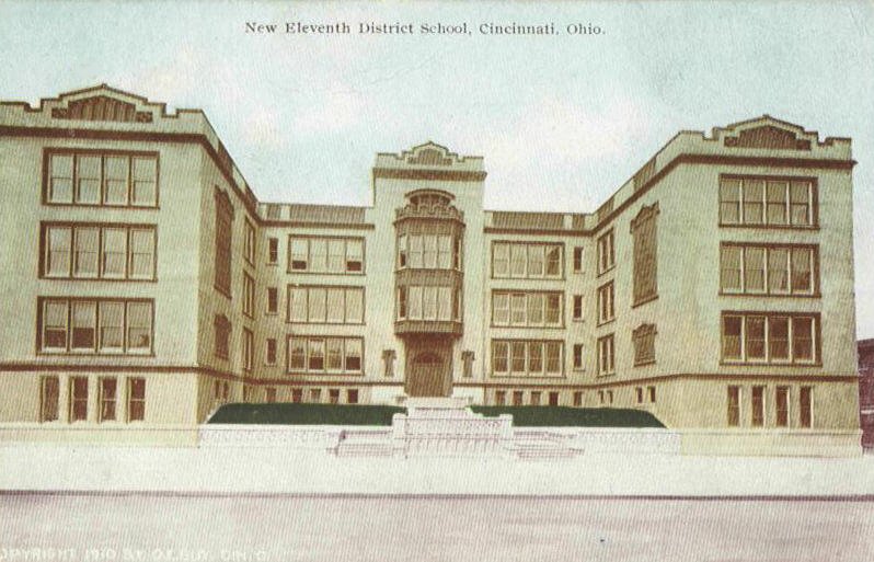
I always like to see pictures of the
places my ancestors lived and worked. I've looked for a photo of Gorman
before without success. This time I searched for images of the 11th
District Public School and found images of the
Washburn School on Clinton between Linn & Baymiller. The interesting thing is that one of the images is
Old Eleventh School District 1907 and notes that the school is about to be destroyed. Another image is a postcard depicting the
New Eleventh School District. Since the map above is the 1904 Sanborn map, one might assume that it is the Old Eleventh School on the map. Guess again!
This is one of the tricky things about the 1904 Sanborn map that
Doug Magee warned us about.
Because of the exorbitant cost of producing maps, from 1904-1930,
corrections were simply pasted into the 1904 map books. A careful inspection
of the Sanborn map reveals that both the school and the annex were
pasted in later. The map shows the New Eleventh School District
building as can be confirmed by viewing the images of the Old and New
Eleventh School.
The Morehouse flat on Gorman could be tracked through
later Sanborn maps (1917, 1922, 1934, 1937, etc.) to get an idea of the
property's transition over time. A list of available Sanborn maps is at
http://goo.gl/gPFlg. But, my Morehouse families had already
moved along.
From a genealogical perspective, tracking the earlier
family properties, determining who owned the flat, and checking the
records of nearby churches and schools just might give me the break
through I am hoping for! First, I'll want to take a closer look at the
1887 and 1891 Sanborn maps and other early maps to see if there are
other even more promising sources of additional information.
If you have made an interesting discovery using the Sanborn maps for Cincinnati, please comment or better yet, write a post!
Update: PLCH has the 1987 Sanborn Fire Insurance Maps digitized and online. However, the library also has a link to Ohio Link where Sanborn Maps dating from 1867 - 1970 are digitized and available online. To get to this site, take the following steps:
- Logon to the library site at: http://http://www.cincinnatilibrary.org/
- Click on "Research and Homework"
- Click on "Research Databases"
- Click on "S" under "Browse Resources by Title"
- Click on "Sanborn Fire Insurance Maps"
- Submit your zip code.
- Begin your search. I have found that one of the most efficient ways to search for a street is to type (Name of street, Cincinnati/Hamilton) or (Name of business, Cincinnati/Hamilton).